Stratigraphy & Contamination Detection
Ground penetrating radar (commonly called GPR) is a geophysical method that has been developed over the past thirty years for shallow, high-resolution, subsurface investigations of the earth. GPR uses high frequency pulsed electromagnetic waves (generally 10 MHz to 1,000 MHz) to acquire subsurface information. Energy is propagated downward into the ground and is reflected back to the surface from boundaries at which there are electrical property contrasts. GPR is a method that is commonly used for environmental, engineering, archeological, and other shallow investigations.
Applications
Environmental Investigations:
| • |
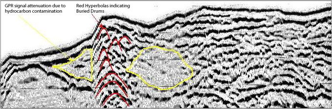
Detection of pipes, drums, barrels, and other metallic and non-metallic objects |
| • |
Detection of hydrocarbon contamination |
| • |
Delineation of vertical and horizontal extent of buried landfills |
Geologic Investigations:
| • |
Soil lithology |
| • |
Depth to bedrock |
| • |
Permafrost detection |
| • |
Groundwater investigation |
|
|
Advantages
| • |
Fast and cost effective |
| • |
Non-Intrusive and Non-Hazardous |
| • |
Operational in arctic environments |
|
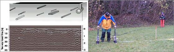
Buried Objects Diagram
The apex of each hyperbola in the GPR profile record above indicate the location and depth of buried metallic and non-metallic objects.
( Click to enlarge)
|
|
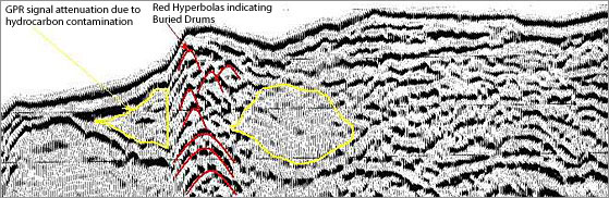
GPR profile record displaying detection of buried drums and hydrocarbon contamination
( Click to enlarge) |
|